

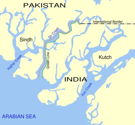

The government of India and Pakistan has exchanged maps marking their respective positions in the Sir Creek marshland during talks in rawalpindi. Both countries also discussed the delimitation of the maritime boundary in the Rann of Kutch on the basis of a joint survey.
The meeting is being termed as a positive step towards making cordial resolution on the dispute over the Sir Creek marshland. The 60-mile long estuary in the Rann of Kutch draws a demarcation line between India’s Gujarat from Pakistan’s Sindh state.
After the meeting in Rawalpindi, both countries issued a joint press statement and said that the two countries discussed about the delimitation of the maritime boundary and the delineation of the boundary in the Sir Creek on the basis of the joint survey done by India and Pakistan.
According to the statement, the exchange of maps and charts has clearly showed the respective positions of both countries on the demarcation of the boundary in the Sir Creek and delimitation of the maritime boundary. After the meeting, both sides have expressed their satisfaction at the successful completion’ of the joint survey of Sir Creek and adjoining areas.
Surveyor General of India Major General M. Gopal Rao had led the eight-member Indian delegation and Additional Defence Secretary Rear Admiral Tanveer Faiz had led the Pakistani team for the talks.
However, there were some claims made by both sides that had put discussion in shadow for some times. Indian team was saying that the Sir Creek boundary actually lies in the middle of the Sir Creek channel while Pakistani delegation was claiming that the boundary line lies on the east bank.